by Nicholas J Casley
Published January 2013
I am indebted to Ray Bush for his ‘rejoinder’, Historical Sources -Useful or a Minefield, that appeared in the last issue of Old Plymouth Today. It should have taught us all to be even more sceptical of assertions presented by some authors as facts, when the author has merely copied from secondary sources. However, please let us not be too hard on our friends Jewitt, Brooking Rowe, Whitfeld, Bracken, Walling et al. Each, in their own way, has contributed a great deal of further understanding of our city’s past by being experts in their own particular field of study, and if they might have erred in their presentation of the facts, then, so long as that misrepresentation is credited to their forbears, they are due the understanding and forgiveness of those historians who follow. After all today’s historians have a greater breadth of vision allied with a deeper grasp of their subject than those that have gone before, and this is partly due to the wider access to primary materials and sources than those enjoyed by the very ancestors we are criticising.
But there is one name in that list of Plymouth historians that I did not mention, a glaringly obvious omission that many of you will no doubt have noted: R.N. Worth. For some reason it seems recently to have become fashionable to denigrate this man for his bumbling archaeological assertions and his inaccurate transcription of historical records. Both accusations can be substantiated, but to poke fun at Worth does him, and all those historians who have and still do rely on his work, a great disservice. To browse through the copies of the transactions of the Plymouth Institution or the Devonshire Association of the late 19th century will reveal a man, who not only demonstrated a strong mental grasp of the intellectual controversies of the day – from church history to geology to Dartmoor hut circles to the Plymouth Leat – but who also was very fastidious in the scientific veracity of the cases he presented, often criticising those who would rely on legend, reputation and belief as the cornerstone of their argument.
In his day he was a man that was looked up to, and no doubt represented on the county scene that epitome of the Victorian polymath. Having such wide interests can, of course, be a two-edged sword, but this is the man who reorganised Plymouth’s municipal records into some kind of order and went on to publish for the benefit of those who followed him the results of his labours therein. No Plymouth historian of the 20th century can ignore his work: Bracken’s history of 1931 can be viewed as a fine-tuned popular version of Worth’s own 1890 History of Plymouth and even 100 years after Worth’s greatest publications our own Crispin Gill can write that Worth’s History has never been bettered, Worth’s greatest service was undoubtedly the publication of his Calendar of Plymouth Municipal Records in 1893, thus providing us all with access to the primary material that was then in the Corporation records. Of course he made mistakes, but to make fun of his great efforts is to mask his triumphs, and we should do well to ponder on how posterity will laugh at our own assertions of our ‘facts’.
But to return to Ray Bush’s rejoinder, I can make no apology for
my plea for sources to be quoted by authors when putting forward their argument. How many of us have read books or articles where mention is made of some ‘fact’, some theory, some item of knowledge, that we did not know before and which may impact radically on the way we have viewed a particular controversy hitherto? Then we look to the footnotes or the endnotes or the acknowledgements or the bibliography or anywhere else for a clue as to where this nugget has come from so that we may judge and, if needs be, check its veracity. Even if it derives from what someone else has already discovered and written about – which, if truth be told covers most works of supposed local history – then the author should make this known.
This is not just for the reader’s benefit: not only does it demonstrate to the reader the author’s breadth of reading on his chosen subject, but it protects the author from his own inflated ego, especially where he attempts to give the impression that he has viewed the primary material, when in fact what he has done is viewed the work of someone else who has eyed the primary source. And, yes, if you are later proved wrong, then the embarrassment is less pronounced when you point out that your assertion of the facts was based on information from someone else that had since been proved erroneous.
May I end where Ray Bush did: the Henry VIII ‘map’ of Plymouth. What I now have to say confirms both Ray Bush’s contention of how much a minefield it can be in dealing with historical sources and my own contention that references to those sources must be given to support an argument.
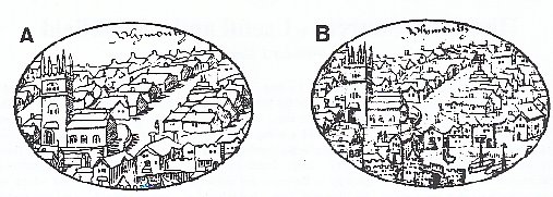
To put it simply, Ray Bush has proposed a view that version A in his article on the Henry VIII map was the original version and that version B was a `retouched’ later copy. But in support of his argument he has given no references. However, I would propose that he has the copies the wrong way round, and in support of my view I will refer to relevant sources. Unfortunately, none of these sources are the original map, but they do give you, the reader, the opportunity of checking my theory. The original map is housed in the British Museum and it is an unfortunate fact that I do not have the time to visit the Museum to verify its authenticity, much as I would wish to.
Instead of this predicament I am going to rely on three sources that I have quickly referred to in my own personal local history library. The first is Worth’s History of Plymouth of 1890, where on page 37 there appears Ray Bush’s version A. Worth describes this print as “from a map in the British Museum.” The important word here is “from”. In other words Worth is not saying that the print is the same as the map in the British Museum, but is a version derived therefrom. Furthermore, on page 233 of his History there is a print of an extract from Ray Bush’s version A relating to St. Katherine’s on the Hoe, and Worth explains in the accompanying text that the engraving is afac-simile from the old
chart temp. Henry VIII,” that is it is expressly not the same as the old chart temp. Henry VIII.
My second source is the cover to Freddy Woodward’s Plymouth’s Defences (1990). Again, this is Ray Bush’s version A, but here Freddy Woodward makes plain that although “the original of the panorama … was drawn in about 1540. This version is after Lysons’ of 1822.” In other words version A is in fact a later version of the original and is here attributed to Daniel and Samuel Lysons, brothers, topographers and antiquaries, whose Devon part of their Magna Britannia was published in 1822. So it would seem that Ray Bush’s version A is after all not the original but an engraved but slightly altered copy “from a chart drawn in the Reign of K. Henry VIII preserved in the British Museum.” Virtually the only way of providing illustrations in books of this period was by way of engraving.
My third and final source is perhaps the clincher of the argument. You may possibly argue that Worth was wrong, but both Worth and Woodward? How about Worth, Woodward and Elisabeth Stuart? This final author has made a special study of ancient maps of Plymouth and wrote a book on the subject, Lost Landscapes of Plymouth: Maps, Charts and Plans to 1800, in 1991. She was formerly the Senior Archivist at the West Devon Record Office and is now employed in London by the Duchy of Cornwall to administer their archives. All I need say here in support of my view that Ray Bush’s map B is the original (and not map A) is to ask you to look carefully at the cover of her book which reproduces in wonderful detail the very map that is held in the British Museum. Here can seen that there is a cross surmounting the gable of Andrew’s church after all; that there are two figures to be seen to south of the church but no low roof buildings; and that the market cross is in the correct position in Buckwell Street. Incidentally, Donn’s 1765 map on page 122 of Stuart’s book shows Holy Cross Lane adjacent to Higher Broad Street (aka. Buckwell Street), the name Broad Street itself being indicative of a market site.
Ray Bush argues that previous historians, including Crispin Gill the late James Barber, have been fooled by the versions available of this map. However, I argue – with important support of reference sources – that they were not for after all. I trust therefore that I have demonstrated the significance of requirement to cite whenever possible the primary or second material upon which the historical argument relies; that ‘facts’ must have their evidence stated to be meaningful.