by Len Stephens
Published May 2012
Plymouth’s history is chiefly centred around its maritime importance and buildings in the Sutton area. We look to Dartmoor for the history of the countryside, yet on the City’s doorsteps is a fragmentation of this countryside. One of our eminent Prime Ministers, William Pitt, Earl of Chatham said that the parks are the lungs of London. It can be said that Central Park is more than just a park, it is the green lung of the City. Best described in the 1943 Plan of Plymouth as “within the city boundary there has been preserved as by a miracle a fragment of typical Devonshire scenery with its sharp contours, its narrow lanes and small woodland”.
How did Central Park come about and why is it necessary to know more of its past in order to preserve its future as part of our heritage? It was bought by the Plymouth City Council in the 1920s when it was a collection of farms and rural land. Its cost was a pittance (well below its market value) but more about that later. I was a young lad when it was opened to the public in 1931 and can well remember the pleasure and health this vast expanse of 234 acres (now reduced to a half) of green fields and countryside brought to the people at a time when a trip to Dartmoor was a luxury. Perhaps it is unfashionable nowadays to prefer Central Park to Roborough Down for a picnic but if the car continues to take over our leisure and we allow the development planners to reduce the green spaces of the park we shall lose the greatest asset that Nature has given us. It is to protect Central Park that I have delved into its past. So little has been chronicled about it that I have examined old maps, surveys and prints to piece together its history. I hope to produce a book but meanwhile this is a short digest.
Its known history dates back to Saxon and Norman times. The Domesday Book of 1086 records the manors of STOCHES (Stoke), WESTONE (later to be Weston Peverell) and MODLEI (Mutley). They had vast areas of woodlands and pasture lands with a number of farms scattered across the area. In the Central Park area of HIGHER SWILLY (the present site of the Ground Maintenance headquarters) at PENNYCOMEQUICK (site of Lower Knollys) and at VENN (from Pounds Park to Ford Park Cemetery). These farms were connected by paths and lanes, some of which still survive, e.g. VENN LANE.
One of the earliest maps of Plymouth illustrates the route of the Plymouth Leat by Robert Spry in 1584, part of which was through the eastern side of Central Park. In Venn Lane, south of Pounds House, there is a stone inscribed “STONEHOUSE LEAT AND BANKS 1593”. The early leat was little more than a stream which provided water to the Venn farms. Another map, that of the fortifications of Plymouth in 1643 shows the earthwork defences to the south of the Park with a fort at Pennycomequick. It is recorded that 17 days after the Sabbath Day Fight at Freedom Fields the Royalist forces under Prince Maurice failed to breach
these defences and withdrew across the open countryside (the Central Park area) driving all the cattle before them.
Benjamin Donne’s Survey & Map Collection of Devon in 1765 is not of sufficient scale to give a clear picture of the Central Park farmlands but it does show an OATLAND GREEN (at the Milehouse end), houses at BELLAIR, POUNDS and TOR and a farmstead at HIGHER SWILLY. It is not until the GARDNER SURVEY 1784, detailing Plymouth and its hinterlands 6″ to 1 mile, that we can ascertain the development of the farmlands of Central Park. The farmhouse at Higher Swilly and a Georgian country house at POUNDS (not the present house, but SPRINGFIELDS) are clearly shown, as is VENN LANE. What is more interesting is that this area was no longer open countryside as the map shows the layout of fields created by Parliamentary Enclosure about 1750. The pattern and hedgerows still exist today and although in recent years modern developments have destroyed some in the north west corner of the Park, it is hoped that the Hedgerow Regulations 1997 will prevent any further destruction.
The Park area starts developing in the 19th century without destroying its rural landscape. Referred to as HUNSCOMBE HILL in a map of 1814 and the naming and numbering of the park fields took place in 1842. The Tithe Apportionment map showed the fields from Pennycomequick to Milehouse Toll Gate bearing numbers only whilst those at Higher Swilly and Pounds carried such names as SHEW PIECE MEADOW, BARN PARK, NEW PARK, HUGHES MEADOW, YEW FIELD, PATH FIELD, WOOD FIELD, YONDER PATH, SEVEN ACRES, BLINE WOOD and LONG FIELD. Most of the names have disappeared. Gilbert’s Lane was well known in those days and in 1830 according to Henry Whitfeld’s History of Plymouth led to a field where bull baiting took place -spectators paying a shilling to see this entertainment. This is probably now the site of HOME PARK.
The gentry of Plymouth were now looking to the green areas around Central Park for their residential homes and by 1830 houses were built at TORR GROVE, MONTPELIER, BELAIR and POUNDS. The latter was built on the site of SPRINGFIELDS by William Hodge, a Devonport banker , and it was the home of the Chapple Hodges for most of the century until the property was conveyed to G.S. and G.G. SHELLABEAR but it was rented to Sir John Jackson (who built the Keyham Extension of the Dockyard and became MP for Devonport) from 1899 to 1914. White’s 1850 Directory shows the Peverell/Pounds area of Central Park as part of Pennycross, a tithing in the parish of St. Andrew in the Roborough Hundred and Plympton Union. The Directory also lists the dairymen farmers who lived at Home Park, Milehouse and Outland, when the Stoke end of Central Park was in the borough of Devonport. The Ordnance Survey maps of 1867 and 1894 give a clear picture of the rural area, the field enclosures are well defined as is the Parliamentary and Municipal Boundary separating Devonport from Plymouth Drake.
There are stones in and around Central Park defining the boundaries of Plymouth and Devonport with dates and coat of arms inscribed. In 1851 the Stonehouse Leat was finally completed with two reservoirs (one storage and one service) being constructed in the Barn Park area, with the leats routed around the south east of the park to Pennycomequick. Here in 1849 the Devonport Prison was built and the picturesque Gothic stone building comprising the wardens quarters and gateway are still standing. At the back of this building in 1865 the Royal Agricultural Society of England held its annual show occupying 30 acres of fields. A similar exhibition was held in 1890 which is why this area of the Park is called Exhibition Field.
No history of Central Park could be written without mentioning Home Park, originally a level field between Gilbert Lane and Higher Swilly Farm where cattle grazed until it was rented to the Devonport Albion Rugby Club who built a sports ground. They vacated it because of a dispute over rental charges and the ARGYLE ATHLETIC CLUB stepped in to secure a long lease on the ground, reopening its gates on Whit Monday 1901 to stage an athletics meeting. During the summer of 1902 Home Park entertained a variety of attractions – a motor cycle race meeting, whippet racing, pony trotting, athletics and cycle events. But the following year professional soccer was to take over when Plymouth Argyle Football Club was inaugurated on the 8th January 1903. Home Park was placed at its disposal on terms similar to those given to the ARGYLE ATHLETIC CLUB.
Plymouth Argyle was admitted into the Southern League and their first league match was against Northampton Town on the 5th September 1903. The attendance was 4,438, ground admission 6d (2 1/2p) and Argyle won 2 – 0. So Home Park was established well before the City bought Central Park, becoming Plymouth Argyle’s landlord.
EYRE’s directories show the residents and occupations of the houses and cottages in and around Central Park at the end of the 19th century and from this we can get a picture of the rural activities which took place. Some of the place names still remain, e.g. LOVE’S FIELD (the first on the left at the Lyndhurst Road entrance to the Park) takes its name from John Love who lived at OUTLANDS before Captain Scott. Anyone born before the First World War would have nostalgic memories of the 1920s period when shows and exhibitions were popular, particularly at the Pennycomequick EXHIBITION FIELD. Here in the early summer of 1922 another BATH & WEST AGRICULTURAL SHOW was held and Crispin Gill in his New History of Plymouth states that its great popularity gave the City the idea of buying this large open space. I can recall, also in the 1920s, being taken as a young boy to the Buffalo Bill’s Wild West Rodeo Show at a field in Lower Knollys. Another attraction at that time was Plymouth Cricket Club who rented their Peverell Park (entrance at the top of Venn Lane) from Lord St. Levan before it was taken over by the City Council. Except for these few areas Central Park was not yet a communal park open to the public but mainly farmland with market gardens and allotments.
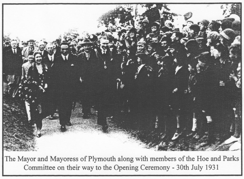
However in the late 1920s the acquisition of Central Park by the City was to become a reality. The first conveyance dated 23rd November 1925 consisted of 201 acres -stretching from Higher Swilly farm and Home Park down to Pennycomequick, taking in all the fields from Milehouse along the eastern side of Alma Road. It was purchased from the Rt. Hon. JOHN TOWNSEND, BARON ST. LEVAN and others at a cost of £87,000. A further parcel of 22 acres (consisting of Pounds House and grounds) was purchased on the 13th June 1927 from Messrs. G. and G.G. Shellabear and H. Hurrell at a cost of £12,356. The third purchase of land on the 31st July 1929, was 18 acres (the Lower Venn, Reservoir and Barn Park area) from Messrs. G. and G.G. Shellabear and H. Hurrell at a cost of £9,900. These three areas of land totalled 241 acres and formed what has now become CENTRAL PARK The purchase worked out at 2 1/2d (1p) a foot and it was obvious that it was the intention of the vendors that the City was to establish an open recreational park free from development. The Hoe and Parks Committee in 1928 commissioned a Landscape Architect, Mr. E. Reuben Mawson to prepare a plan for the layout of Central Park and his report was presented to the Committee on the 31st October 1928.
The MAWSON plan like the 1943 Plan for Plymouth was an important visionary document and it will warrant a whole chapter to be devoted to it. For the present I will say that many of its recommendations were implemented including the following:
(i) Tennis Courts (subsequently removed in recent years)
(ii) Facilities to be provided for bowls, three children’s playgrounds (the largest has been removed), children’s play pool and boat pond (subsequently removed), putting green (subsequently removed), and playing fields for football, rugby, cricket and hockey (some now removed)
(iii) A four acre nursery (what is left of it now?)
Among some of the recommendations that were not implemented but were ahead of its time were a “wild” garden, an aviary and a rhododendron lined walk between Pounds House garden and the main park.
The layout development of the Park began in 1929 when the “first
—————— MISSING TEXT —————-